Category: Blogs

Thoughts and recent events.

  • A Hundred-mile Jaunt over the Prairies of Southern Alberta

    A Hundred-mile Jaunt over the Prairies of Southern Alberta

    I always get nervous a few days before a big ride with other people, even a Gran Fondo that is not supposed to be competitive.  However, this Fondo had chip-timing for the serious routes despite its small size.  There were 150 timed riders and the same number of riders for the childrens’ and minor distances.  However, just 35 of the total 300 were tackling the 165km (100 mile) route.  I thought I had prepared okay for that distance but when I remembered back to the Red Bud Century Ride in April, I recalled running out of steam for the last 30km.

    The C4 Fondo has been running for 3 years and attracts riders from all over Alberta who want to challenge themselves and enjoy the rolling prairie routes.  The event is a prime fund-raiser for the Cardston Community Cycling Club (C4) whose aim is to promote cycling as a healthy activity for their youth.   As Cardston is an isolated town with limited hotel choice, I  stayed in Lethbridge the night before as its only 50 minutes away and has a wider range of facilities.  

    Having collected my registration package on the Friday evening,  I could afford to roll up to the start line on Saturday morning, ten minutes ahead of the course briefing.  There was plenty of parking at the assembly area so my only last-minute decision was what to wear.  I looked at weather, sunny and 13⁰C, so decided on my Gore jacket with zip-off sleeves.  Most of the younger riders wore short-sleeved cycle jerseys, expecting to warm rapidly on the climb up to the US border.

    Welcome support on the route from the C4 organizers

    At precisely 8 am, we were released through the start gate.  I stayed nearer the back initially as our group climbed the gentle incline that comprised 4 Street.  We levelled for a few hundred metres after turning south but then hit the steep ramp I knew was coming.  Young muscles powered their riders up and away from me and I realized this would be the last time I would see them except when they were returning from the turnaround locations. 

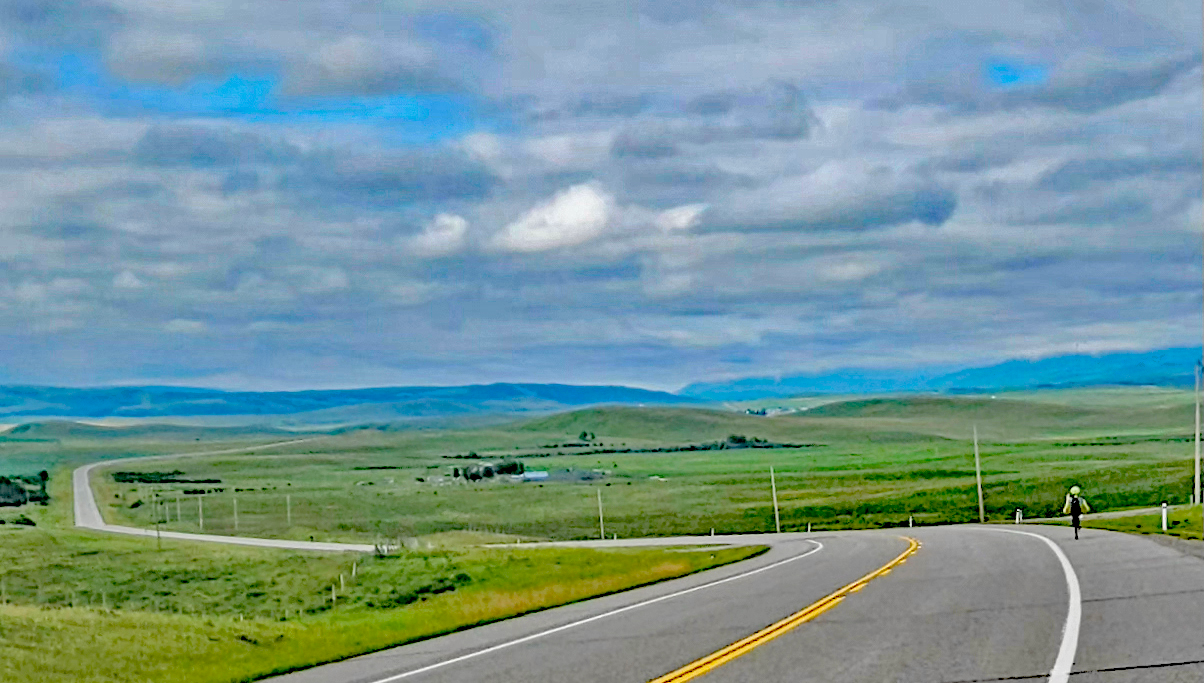
    The route comprised three limbs that each included a long climb and descent, though the total amount climbed was a little under 1300m, so not that high for a 165km event.   Our initial limb lead us south on the road to the US border crossing at Carway, which,  I discovered  later was merely a name on the map with no settlement.  After that initial 12% ramp, the incline dropped but the road continued upwards for the next 18km. Then, the last few kilometres to the border undulated downhill. 

    Some four kilometres from the border, the fast group came back past me returning to Cardston.  Slowly a group of three of us coalesced, comprising me and two female riders who were at about the same level of fitness, despite the disparity of ages and gender.  We worked together well and certainly pushed each other more and rode faster than we would have as individuals.  At first, Caitlan, a younger rider struggled on the hills but she was great at pulling in front on the flat.  I couldn’t climb as fast as Barb, a 50+ category rider, but was more than happy to take long pulls on the front.

    None of us was particularly concerned with the chip timing so we stopped for water, bananas and snacks at the aid station back in Cardston.   Having competed the southerly limb, we now struck west on the main road towards Waterton Park. Our pre-ride briefing instructed us to ride on the shoulder which was fine as this was a wide strip of smooth asphalt, except at gravel road intersections.  The two others rode hard on this stretch and  I had to fight to stay with them on the climbs.

    At around 80km, our route turned north off the Waterton road, down on a long drop towards Hill Spring our northern turning point.  We appreciated the downhill but noticed a north easterly wind was picking up. That wind might have helped us some on the way back south but I wasn’t looking forward to the 17km of climbing back to the main road.  As I feared, I began to lose the wheel of the others on the climbs but they were patient, enabling us to remain together for the ride west to the aptly-named Mountain View turnaround. 

    Caitlin pulling in the front with Barb behind sheltering me

    The weather remained fine with the temperature climbing into the low twenties and a fierce sun burning  but, after turning at Mountain View, we knew we would be climbing more long hills and riding home into a headwind. There had been no wind when we set off in the morning but it gradually built up over the five hours we had been riding so it became important for us to ride tightly together. 

    The return distance to Cardston was around 39km but  I found it increasingly difficult to generate the same power as I had at the start.  Barb was silently suffering from  a dead foot but, surprisingly, Caitlin was  finishing strongly.  In fact, she rode off on her own some ten kilometres from home and both Barb and I were happy to let her enjoy her first bike event and to finish it at her own pace.     

    Caitlin, Barb and Ron at the Finish line after 6 hours of tough Riding

    The pair of us rode over the line just after 2pm, having taken 6 hours 8 minutes on the clock and 5 hours 54 minutes on Strava..   When I looked at my result relative to the other 35 riders,  I found I was well down the list, but all those participants were serious cyclists.  This wasn’t like other Gran Fondos I have ridden where there were people just riding to see if they could actually complete a 100-mile course. 

    Route headed south to US border, back to Cardston then west to Hill Spring and finally to Mountain View before riding back to Cardston

    I certainly had a great day on the bike and I really appreciated the efforts of the Cardston Community Cycling Club to welcome us and to arrange a first class event.

  • When is a Bike not a Bike?

    When is a Bike not a Bike?

    Until a few years ago this wasn’t  an issue as the only motor that could provide enough power to move or even assist a cyclist was a gasolene fueled internal combustion engine.  Once the engine was integrated with the frame, the machine was effectively a motorbike in most jurisdictions but, in Europe after the Second World War, bikes like the Velosolex  were produced with a small auxiliary motor that was mounted above the front wheel with a friction roller that could be lowered to drive the tire.   This type of machine never made inroads into Britain or North America and by the time true mopeds were introduced in the 1960s and 1970s, they were considered just low-powered motorbikes, albeit with working pedals that could move the machine if you were desperate.   

    However, the remarkable development of efficient lightweight batteries in the 21st Century has generated a deluge of electrically powered bikes that have been categorized differently to traditional motor bikes.  The drive to promote “green” mobility with these machines, and so  reduce car usage,  has resulted in them being treated  more benevolently by authorities than their gasolene-driven counterparts.  So much so, it seems, that the definition of a motor bike has been blurred.  There is no worldwide agreement on the definition of a bike with electrical motor assistance (what we term an e-bike) and a pure electric motor bike although there are some common themes. 

    In the European Union, Britain, Japan, Korea, Australia , South Africa and Russia e-bikes are limited to 250 Watts

    The essential characteristics of a conventional bicycle are that it is powered by the rider and is relatively lightweight. Speed is mostly limited by the gradient of the road, the tire and air resistance, and the power the rider can generate to overcome these.   An untrained, recreational cyclist can sustain say 100 to 150Watts for an hour, while a good club rider might put out 200 to 300Watts.  An elite world class rider could maintain 400 to 500 watts, so how do these values compare with the power assistance given by e-bikes?

    In the European Union, Britain, Japan, Korea, Australia , South Africa and Russia e-bikes are limited to 250 Watts but this consensus is not met in North America.  Canada accepts e-bikes of up to 500Watts on the road while the USA and Mexico allow the power to be as high as 750W.  On the face of it,  we are giving an untrained cyclist in Canada as much power as a world class elite athlete, even before they add their own pedal power.  In the USA and Mexico, the power available is completely inconsistent with the rest of the world’s  interpretation of providing electrical assistance.        

    Fortunately, we are not seeing e-bikes whirling past us at 60kph on the cycle trails because there is also legislation in place that limits the maximum speed of e-bikes to 20mph (32kph) in both Canada and the USA. These bikes can go faster if the rider also pedals or goes downhill.  In contrast, in Europe the available power is reduced from 250W when the bike reaches 30kph. 

    With the extra power available in North America, we do see a greater number of heavier machines such as cargo bikes, fat tire cycles and mountain bikes. In hilly and rough terrain, there is an argument for needing more power to move these machines but there is the potential problem they pose when mixing with pedestrians or lightweight cycles on mixed trails.  Then there is the problem of riders using bikes intended for off road on public roads.   

    Bikes such as the Velotric Nomad 2 are currently being sold in Canada with 750W available power, a top speed of 45kph and a carrying capacity of 560lbs (250kg). The marketing blurb advises purchases that there may be federal or provincial regulations that limit the speed on public roads but it is up to the rider to comply.  Strictly, such a bike can not legally be used on the roads here because of their power, even if ridden below 32 kph.  It seems likely, though, that these machines will migrate onto our bike trails and roads around Calgary as there is no effectively way of policing them.   

    Is that the end of the story?  Sadly, not because also sharing our bike trails are electric scooters and the phenomenally fast electric unicycle (EUC).  Some of these EUCs being sold in Canada boast 3000W of power and 90kph making a total mockery of any bike regulations.  In some countries, like Germany, they are illegal for use on roads, cycle paths and sidewalks, while other countries like Switzerland treat them like motor vehicles and require a licence plate and insurance.  Here in Canada, we are still playing catch-up with regulation.  There are no Federal controls but some provinces treat them as e-bikes with speed and or 500W power restrictions. However, here in Alberta we have not defined their status. Calgary allows them on bike paths provided they adhere to the 32kph limit.

    So, when is a bike not a bike?  In my mind anything that cannot be pedalled and that generates more power than an elite athlete should not be regulated as a bike.    What are your thoughts?

  • My Favourite 50km Route

    My Favourite 50km Route

    This is a ride of 50km, that can be clipped to 40km for winter, and is one of the most enjoyable in Calgary.  Essentially, you ride down one side of the Bow River and return via the opposite bank.  Although I ride from Downtown, you can start this ride from a number of free parking locations around the circuit:  Renfrew Off-Lease Parking Lot, Old Refinery Park,  Carburn Park,  Douglas Ball Park, Fish Creek Loop Parking, Fish Creek (Bankside or Mallard Point), Sue Higgins Dog Park and Graves Bridge Boat Launch as a few suggestions.

    One of the key features of the ride is that there is no riding on roads as all 50km is on dedicated trails. True you have to monitor pedestrians and dogs but, outside the riverside parks, these hazards become fewer and the users are mostly other sports cyclists or bike commuters.  On the east side of the river, you cross a total of three roads, two of which are dead-end drives to golf courses and the third is via a controlled crossing at the Zoo bridge. (The underpass there remains closed for construction.)  On the west bank there are several quiet residential  roads to cross as you pass through Inglewood.

    Another feature of the ride is the provision of rest room facilities year round, at St Patrick Island, Carburn Park, Fish Creek Bankside and Fish Creek Mallard Point, and seasonal facilities in Prince’s Island Park and Douglas Ball Park.  Cafes tend to be clustered downtown  and in Inglewood but for the 2 to 2 ½ hours I need for this route, I normally take my coffee back at home.   

    Starting from downtown on the busy Bow Valley trail you can’t help but notice the newly finished Eau Claire Plaza opposite Prince’s Island Park. Bright yellow sunshades and loungers sit in an artificial beach of sand with the incongruous backdrop of city skyscrapers to the south.  Avoiding other cyclists and errant pedestrians here, you make your way over to St Patrick’s Island with its strange street light sculpture that serves as a nesting platform for ospreys in the summer.    If you’re lucky enough, further south when riding on the east ridge above the river,  you may spot an osprey hovering briefly at your level before it plunges down in search of fish.

    The bench and viewpoint on the Bow River at the Calgary Zoo

    Beyond St Patrick’s Island you pass between the two sections of Calgary Zoo, under the connecting bridges and round to the Nose Creek confluence where an inviting bench offers a view up and down river.    You continue down river but depart for a while to cross over the main Deerfoot Highway  on the footbridge that leads towards  to the Max Bell Centre.  Below you is the outflow where the Western Headwaters Canal starts.

    Vietnam Boat People Memorial on 17 Avenue above the Western Headwaters Canal

    On reaching the canoe slalom course, you spiral up past the Vietnam Boat People Memorial and back over the canal, descending down to ride along its west bank, passing under the Deerfoot trail through a chicane where  the bridge girders are so low they almost graze your helmet.  Separating you from the Bow River is the  Inglewood Golf Course that necks down before you cross a little-used siding from the Canadian Pacific shunting yard.  Looking right over the river along the course of the railway line you get a great view of the downtown skyline.

    Low headroom as your ride under the Deerfoot Highway 2

    The  50Avenue overpass near the Brick furniture warehouse is your cue to recross the canal, climb to 50 Avenue and then cross back over the canal, the railway and the Ogden Road. Continuing your anticlockwise manoeuvre, you descend under 50 Ave and turn onto the bow River Pathway passing through Old Refinery Park to reach the river itself.   Follow the Bow River Trail south, and prepare yourself for a short steep climb up to the ridge that affords distant views of the Rockies on clear days.

    Sadly, after gaining all that height, you lose it again to drop down under the Graves Bridge and the Glenmore Trail. Along the next stretch of river, American White Pelicans are often seen in summer by the islands in mid-stream.     Carburn Park can be busy a little further along  and the route continues through parkland until you go under the Deerfoot Trail again.  There’s long-term construction at the bridge and the adjacent Enmax substation so watch out for traffic controllers.

     At Douglasbank Park, you have the option to cut 10 kilometres from the route by crossing the river on the Sue Higgins footbridge.  400m south of the bridge , in the Mallard Point parking lot, are spacious, heated washrooms that give welcome respite from the weather on a cold winter’s day!  Should you remain on the east bank, there’s another climb ahead of you but the vista from the ridge is ample repayment for your efforts. Views over Fish Creek Park stretch on forever, while ahead of you the river sparkles in the sun. 

    Wonderful view south from the ridge over Fish Creek Park

    Theres one more descent on this side of the river to take you down to the McKenzie Bridge (South Fish Creek)  as this is the turning point on your journey.   Wide, newly-paved trails carry you north through Fish Creek Park, where, with luck, a tailwind will speed you back across the flats to Mallard Point. (Your river crossing point if opting for the short course.)   On this side of the river, there’s  one short but steep climb at Diamond Cove and then an immediate drop down to ride under the east side of the Deerfoot Bridge.

    The trail is flanked on the left by industrial yards whose fences hide oncoming traffic so take care here as you pass through to reach the Sue Higgins Dog Park with its yellow painted speed humps and mini roundabouts aimed at slowing you where footpaths cross your trail to access more dog park by the river.  Opposite the luxury car distributors on Heritage Road is a fenced off area of land where deer and other wildlife can roam unhindered.  

    Buck deer with new velvet on its antlers seen in the enclosed wild area off Heritage Road

    Graves Bridge has a parking lot and public boat launch that is often used as a take-out for commercial rafters.  Your route  follows the river bank closely here,  past the golf range and more industrial yards and under a long tunnel where the air is notably colder than the ambient temperature  both in summer and winter.  On the railway bridge next to Ogden Road, you often see freight trains crossing the main river and the cycle path here takes an interesting loop under the second railway bridge on a balcony that juts out over the river.  In winter, it can be quite disconcerting to find yourself suspended over a jumble of ice and freezing water on this balcony.

    View from the balcony over the Bow River with CP locomotive shunting trucks on the parallel bridge

    Railway sidings keep you company from here as far as Inglewood Meadows and the Bird Sanctuary. Rounding houses in Inglewood, you pass the bike pump track, duck under the Cushing Road bridge and enter the woods at Peace Estate Park.  Again, you need to be aware of other path-users here but its worth detouring to watch rafters and paddlers on the slalom course that has been crafted in the nearest reach of the river.  

    There’s no riverside trail option when you reach  15 Street SE so you have to take the path next to local roads  until you can return to the river at 13 Street.  This might be a good time to take a coffee break at Good News Coffee located where 15 Street SE meets up with 17 Avenue and 9 Avenue.    The river trail from 13 Street westwards to the Elbow confluence has been reopened so you no longer have to take the road detour along 8 Avenue that was never great in winter.  

    From the Elbow, you simply follow the cycle path next to the Riverwalk into downtown. On the way there coffee options at Sidewalk Citizen Bakery, Café Gravity or the Hutch Café and Alforno Bakery and Café if you decide to go as far as the  Peace Bridge before turning back.  

    I hope you will enjoy the route as much as I do.

  • Stampede Curiosity – Trails around the Stampede Grounds

    Stampede Curiosity – Trails around the Stampede Grounds

    • Curious as to how the cycle paths were affected by the Stampede, I decided to ride around the outside of the Grounds and see for myself.  I only expected to ride about 10km from downtown, up the Elbow River from its confluence with the Bow and then back down the Main cycle path paralleling 5 Street SW.

      Expecting pedestrian and road traffic, I donned a fluorescent yellow jersey and ensured both my front and rear high intensity flashing lamp and bell s were working.  On the Bow Valley Trail, there was some cyclists but thankfully few electric scooters as I made my way downriver to the Elbow River.  Hazy sun kept the temperature at a comfortable 25⁰C with a light easterly wind barely ruffling the CS flags advertising the Stampede.

      Most pedestrians appreciated me dinging my bell on approach  but not everyone heard or reacted as though they had heard so I kept my speed down.  I was using this ride as a low intensity training ride for my Trainer Road program so didn’t mind the slowing and stopping occasionally. 

      There wasn’t much to see  in the First Nation’s camp on the Elbow as the participants’ trailers blocked most of the view until I found a set of stairs up to Scotsman Hill  in Ramsay. This vantage point  that gave me a fine overlook of the camp and the grounds beyond with its backdrop of the downtown skyscrapers.   The path that hugged the Elbow River was blocked at the Stampede Trail so I had to ride onto 25 Avenue and make my way past the Erlton entrance and cross the MacLeod Trail on 25 Ave to reach the cycle path on 5 Street SW. 

      Heading north on 5 Street SW, it isn’t clear if the cycle path  is initially in the road or on the side walk but this becomes clear at the bustling intersection with 17 Ave SW where the cycle path  continues northwards separated from 5 Street that is one way southwards only.  I have always found the flow of this major north-south cycle route into town to be interrupted at just about every other intersection so clip-in pedals are a disadvantage unless you can trackstand for a full traffic light cycle.

      A scooter and a rider on an electric bike caught me up by the traffic counter as we waited to cross 9 Avenue.  I was the 971st rider past the counter that day though whether that  is a high number or not I don’t know.   As we pulled away, the scooter stayed behind me while the electric bike overtook and continued some ten metres ahead of me.   Then, without any warning a pedestrian stepped into the bike lane intent on crossing the road.  Whether he had assumed any traffic would only be coming from his right or not, I didn’t discover but at some 200lbs he was big enough to knock the electric bike over and send the rider sprawling into the road traffic lane.

      Luckily, the rider didn’t appear to be hurt but had a graze down his right arm. The pedestrian, who hadn’t gone down, helped him up and, between us, we straightened the bike’s handlebars.  I heard the pedestrian muttering something about not seeing him as I rode off to be overtaken again by the electric bike a couple of blocks further north.  It was a sobering warning for me of the random hazards you need to be wary off riding downtown, even in separated bike lanes.   It was even more sobering to learn later that a cyclist had been fatally injured in a collision with a dump truck earlier in the day in the city’s southwest.  

  • How did I get to Calgary?

    How did I get to Calgary?

    About Me

    This blog begins with a bicycle journey to Calgary across the mountains from British Columbia.  The story explains, indirectly, how I ended up living in this city as well as giving you an insight to my love of the bike and in riding long distances.

    It was the second summer of the Pandemic so while there were some interprovincial travel restrictions, these didn’t stop travel from British Columbia to Alberta.  The previous summer  in   2020, I had made a journey over the Rockies from Chilliwack to Jasper where my son worked at  the Lodge.  Now, in 2021, I had planned different route over the mountains to my daughter’s home near Nosehill Park in the northwest of the city.

    The 1,200km route I had chosen from Chilliwack hugged the American border as far as Cranbrook and then struck north between the Purcell and the Rocky Mountains to Radium Hot Springs, where I would cut over the mountains to Castle Junction in the Bow Valley and then follow that river on the old Highway 1 through Cochrane and into northwest Calgary. From my experience riding to Jasper, I knew I could make it in six days.  

    I like to travel fast and light on a bicycle. This results in less days on the road and, in the summer, speed keeps you cooler and allows you to outpace most bugs.   While I could have made the journey unsupported,  my wife Jane readily accepted a driving role.  Our strategy was for me to leave very early in the morning and she would depart some three hours later catching me up after four hours of cycling.  We’d swap out drink bottles, I’d take on more snacks and then she’d drive ahead to me again two hours later.  For a  ride longer than eight-hours, we’d repeat our meet up another two hours down the road.   Mostly, this strategy worked.

    Unknown to us before I departed on Sunday 20th June, an unprecedented heat event was developing in southern British Columbia.  Nothing appeared unusual as I set off at first light into a gentle headwind. In fact, a drizzly shower peppered me as I crossed over the mighty Fraser River at Agassiz on the skinny two-lane bridge that most cyclist dub the scariest in the Lower Mainland.  At the time of day I crossed though, there was little traffic to harass me.  

    Riding towards Hope, I was in familiar territory as this was the same road I had taken to Jasper the previous year and where, more recently, I had made my longer training rides.  However, climbing up into the Coastal Mountains east of Hope I was into new ground.  Driving that road up to the Manning Park you just don’t realize how relentless the grade is but the views of mountains and the fast-flowing Skagit River compensated for my slow cycling pace.

    At Manning Park Lodge, I rendezvoused with Jane and enjoyed a sandwich in the picnic area along with dozens of day-trippers and vacationers passing through to the interior.  By then it was midday and the heat was building even at that elevation of  1,200m.  Curious Columbian ground squirrels popped their heads out of burrows in search of crumbs.  These ground squirrels are distant cousins of the smaller Richardson ground squirrels we see here,  once the snow melts.

    By the time I reached our Airbnb accommodation in Princeton, I was starting to wilt from the effort of riding and temperature, so the long cool drinks Jane plied me with were just what I needed. Those and a huge pasta meal to replenish lost glycogen.

    I had no illusions the next day would be any easier as I had to ride through Osoyoos, well known for having some of the highest summer temperatures in Canada.  By then we also knew a so-called “heat dome” was developing behind us and tracking eastwards.  Even so, when I departed the air was pleasantly cool and the initial riding was gently downhill following the lyrically-named Similkameen River.    

     I had to climbed over the ridge into the Osoyoos Valley, first passing by the geographical oddity of Spotted Lake before making the fast descent to my rendezvous in Osoyoos where the temperature was already in the low 30’s C.  A break in an airconditioned Tim Hortons revived me temporarily but did nothing to prepare me for the brutal ascent up Anarchist Hill on the far side of the valley.  Granted I was moving slowly but I was managing  to grind my way up the hill on tar that was beginning to get tacky in the relentless sunshine.    That was, until I reached a roll-over accident where a gravel truck trailer had flipped on the descent, blocking the road.  

    With no alternative, I had to turn back as there was no easy detour around the blockage. I had ridden 132km but couldn’t get to Greenwood without arranging for a ride with my support car. We made a massive detour through Kelowna and by the time we returned to Highway 3,  I had no appetite to ride the last 30km to British Columbia’s smallest city.  Frustrated at having not been able to keep riding, I prepared myself for the next day that featured two huge climbs totally over 2,300m.

    The road was empty when I set off at dawn and as the day brightened logging trucks began to appear, headed for the mill in Grand Forks. Further east the Kettle valley gave me some respite before a thousand metre climb to Paulson Summit.  Beyond was my reward of a 30km descent to the Columbia River at Castlegar.    During that descent, I had a scare with high-speed shimmy on the front wheel, something I had experienced a couple of times before on the Roubaix road bike.  Intriguingly, I concluded that I was causing the oscillation myself with my twitching, tired arm muscles. Once I dared to take one hand off the handlebars the oscillation disappeared!

    I hid in another air-conditioned fast-food restaurant at Castlegar, drinking a litre of ice cold coke and not wanting to go back into the withering heat.  Facing 40km more riding and one more big climb of 700m, I reluctantly left and set off for accommodation in Salmo.

    Day 4 was a tough one featuring a thousand metre climb followed by a decent to Creston and then a hundred kilometres of slowly rising terrain to Cranbrook. The 20km climb seemed never ending and my only reward was the 30km drop to Creston, a British Columbian town that sticks to Mountain Standard Time year-round.  In summer that  time is the same as Pacific Daylight-saving Time so no clock changes we necessary.  As I made my way further east, I noticed clouds developing and sensed a change in the weather was coming.   Later from our hotel room at Cranbrook, I observed the sky turning dark, preceding a violent thundery rain storm where the streets ran with water that couldn’t drain fast enough. 

    When I set off the next day, it was still dark and street lights reflected off puddles in the road.  The rain had stopped but I donned a jacket to stay dry from the spray. I was headed north along the Rocky Mountain Trench through Fairmont Hot Springs and Windemere. Luckily a southerly wind helped my progress and soon dried out the wet road surface.  Vacation traffic was  busy by the time I reach Radium Hot Springs and turned up though the narrow gorge on the cut through to Banff.

    The terrain climbed beyond Radium Hot Springs and gave me a wonderful open view of the Kootenay River after the highpoint.   Down in the Kootenay Valley, my tired legs appreciated the gentle grade and I found the wild landscape therapeutic enabling to enjoy the final climb up the Vermillion Valley to Kootenay Park Lodge.  In that second pandemic year, the Lodge was up for sale and appeared to be struggling to survive.

    With the temperatures I had experienced on this venture up to that point, I had forgotten how cold it could get in the mountains, even in summer.  So, when I set off without gloves on my final day, I was soon struggling to keep my hands warm.  The further I climbed to cross over to the Bow Valley, the colder my hands got.  Then I had the exhilarating descent to Castle Junction but I didn’t appreciate this as it was all I could do to stop shivering uncontrollably. 

    Eventually, I warmed up enough on the Bow Valley Parkway to enjoy the ride to Banff and to take in the majestic mountains south of the Bow River.  Carrying on through Banff,  I followed the cycle trail to Canmore, meeting up with Jane for a celebratory breakfast at the Summit Café in Cougar Creek.  By then, I was warm enough to sit at an outdoor table that afforded an excellent view of the Three Sisters ridge across the valley.

    I couldn’t linger for too long in Canmore as I was only half way to my destination in Calgary.  I found Highway 1A east of Canmore busier than I had expected and got held up for a while at a railway crossing before making my way past Ghost Lake to Cochrane. After  brief pause at the Ranche parking lot, I had to fight my up Cochrane Hill as  by then I was really feeling the six days of accumulated fatigue in my legs.  

    Not really knowing my way around Calgary and not wishing to ride in afternoon commuter traffic,  I agreed with Jane to halt just inside the city limits at Tuscany.  When I stepped of the bike, I was exhausted to the point of needing to sit still for five minutes before  loading the bike on the car and driving the final 15km to  my daughter’s house.  

    In a roundabout way, this is the story of how I got to move to Calgary. When we arrived at my daughter’s door, my first grandchild greeted us at the door and this welcome subconsciously set in to motion the wheels that lead us to live in the city less than three years later.