This is a ride of 50km, that can be clipped to 40km for winter, and is one of the most enjoyable in Calgary. Essentially, you ride down one side of the Bow River and return via the opposite bank. Although I ride from Downtown, you can start this ride from a number of free parking locations around the circuit: Renfrew Off-Lease Parking Lot, Old Refinery Park, Carburn Park, Douglas Ball Park, Fish Creek Loop Parking, Fish Creek (Bankside or Mallard Point), Sue Higgins Dog Park and Graves Bridge Boat Launch as a few suggestions.
One of the key features of the ride is that there is no riding on roads as all 50km is on dedicated trails. True you have to monitor pedestrians and dogs but, outside the riverside parks, these hazards become fewer and the users are mostly other sports cyclists or bike commuters. On the east side of the river, you cross a total of three roads, two of which are dead-end drives to golf courses and the third is via a controlled crossing at the Zoo bridge. (The underpass there remains closed for construction.) On the west bank there are several quiet residential roads to cross as you pass through Inglewood.
Another feature of the ride is the provision of rest room facilities year round, at St Patrick Island, Carburn Park, Fish Creek Bankside and Fish Creek Mallard Point, and seasonal facilities in Prince’s Island Park and Douglas Ball Park. Cafes tend to be clustered downtown and in Inglewood but for the 2 to 2 ½ hours I need for this route, I normally take my coffee back at home.
Starting from downtown on the busy Bow Valley trail you can’t help but notice the newly finished Eau Claire Plaza opposite Prince’s Island Park. Bright yellow sunshades and loungers sit in an artificial beach of sand with the incongruous backdrop of city skyscrapers to the south. Avoiding other cyclists and errant pedestrians here, you make your way over to St Patrick’s Island with its strange street light sculpture that serves as a nesting platform for ospreys in the summer. If you’re lucky enough, further south when riding on the east ridge above the river, you may spot an osprey hovering briefly at your level before it plunges down in search of fish.

Beyond St Patrick’s Island you pass between the two sections of Calgary Zoo, under the connecting bridges and round to the Nose Creek confluence where an inviting bench offers a view up and down river. You continue down river but depart for a while to cross over the main Deerfoot Highway on the footbridge that leads towards to the Max Bell Centre. Below you is the outflow where the Western Headwaters Canal starts.

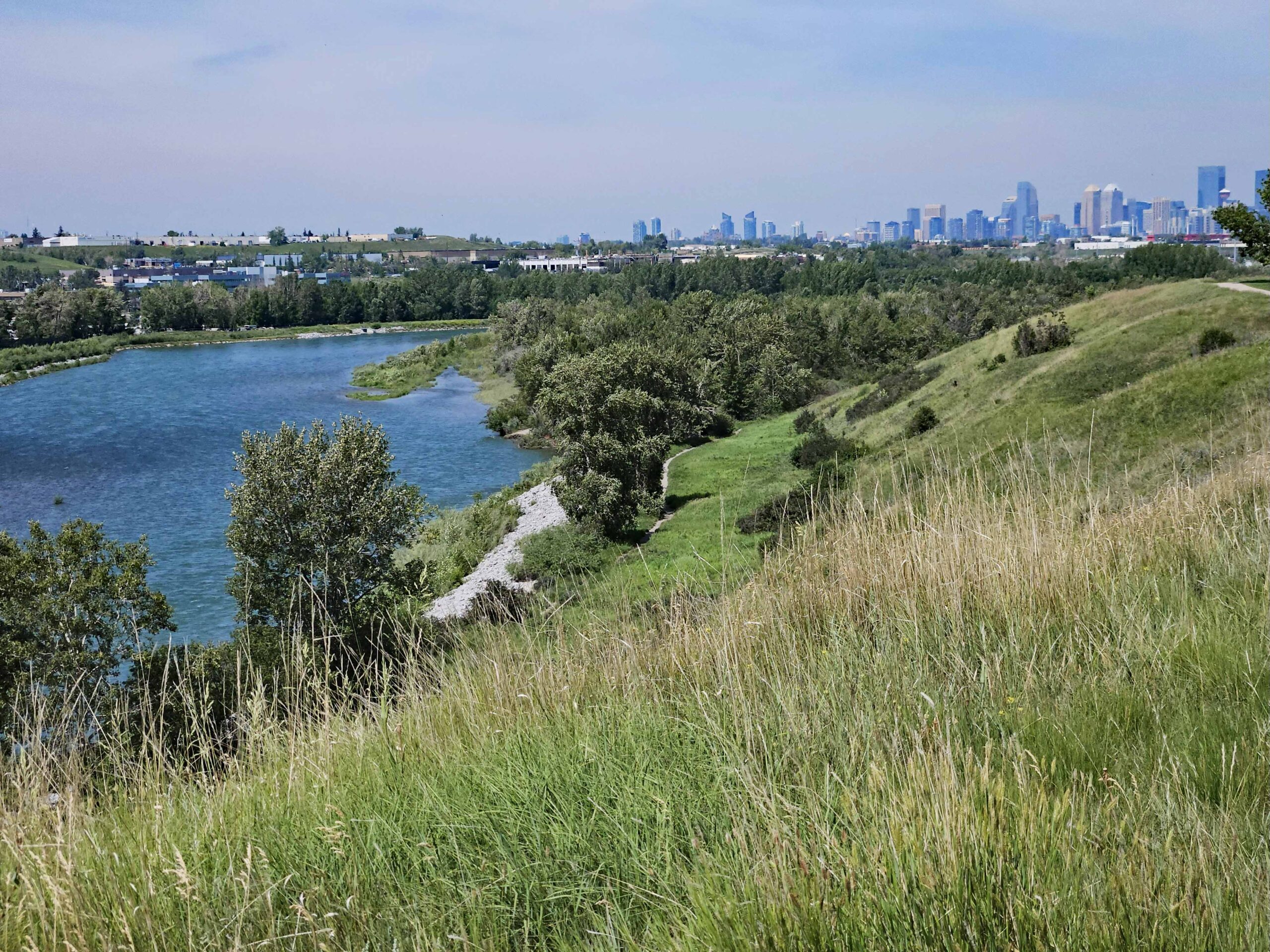
On reaching the canoe slalom course, you spiral up past the Vietnam Boat People Memorial and back over the canal, descending down to ride along its west bank, passing under the Deerfoot trail through a chicane where the bridge girders are so low they almost graze your helmet. Separating you from the Bow River is the Inglewood Golf Course that necks down before you cross a little-used siding from the Canadian Pacific shunting yard. Looking right over the river along the course of the railway line you get a great view of the downtown skyline.

The 50Avenue overpass near the Brick furniture warehouse is your cue to recross the canal, climb to 50 Avenue and then cross back over the canal, the railway and the Ogden Road. Continuing your anticlockwise manoeuvre, you descend under 50 Ave and turn onto the bow River Pathway passing through Old Refinery Park to reach the river itself. Follow the Bow River Trail south, and prepare yourself for a short steep climb up to the ridge that affords distant views of the Rockies on clear days.
Sadly, after gaining all that height, you lose it again to drop down under the Graves Bridge and the Glenmore Trail. Along the next stretch of river, American White Pelicans are often seen in summer by the islands in mid-stream. Carburn Park can be busy a little further along and the route continues through parkland until you go under the Deerfoot Trail again. There’s long-term construction at the bridge and the adjacent Enmax substation so watch out for traffic controllers.
At Douglasbank Park, you have the option to cut 10 kilometres from the route by crossing the river on the Sue Higgins footbridge. 400m south of the bridge , in the Mallard Point parking lot, are spacious, heated washrooms that give welcome respite from the weather on a cold winter’s day! Should you remain on the east bank, there’s another climb ahead of you but the vista from the ridge is ample repayment for your efforts. Views over Fish Creek Park stretch on forever, while ahead of you the river sparkles in the sun.

Theres one more descent on this side of the river to take you down to the McKenzie Bridge (South Fish Creek) as this is the turning point on your journey. Wide, newly-paved trails carry you north through Fish Creek Park, where, with luck, a tailwind will speed you back across the flats to Mallard Point. (Your river crossing point if opting for the short course.) On this side of the river, there’s one short but steep climb at Diamond Cove and then an immediate drop down to ride under the east side of the Deerfoot Bridge.
The trail is flanked on the left by industrial yards whose fences hide oncoming traffic so take care here as you pass through to reach the Sue Higgins Dog Park with its yellow painted speed humps and mini roundabouts aimed at slowing you where footpaths cross your trail to access more dog park by the river. Opposite the luxury car distributors on Heritage Road is a fenced off area of land where deer and other wildlife can roam unhindered.

Graves Bridge has a parking lot and public boat launch that is often used as a take-out for commercial rafters. Your route follows the river bank closely here, past the golf range and more industrial yards and under a long tunnel where the air is notably colder than the ambient temperature both in summer and winter. On the railway bridge next to Ogden Road, you often see freight trains crossing the main river and the cycle path here takes an interesting loop under the second railway bridge on a balcony that juts out over the river. In winter, it can be quite disconcerting to find yourself suspended over a jumble of ice and freezing water on this balcony.

Railway sidings keep you company from here as far as Inglewood Meadows and the Bird Sanctuary. Rounding houses in Inglewood, you pass the bike pump track, duck under the Cushing Road bridge and enter the woods at Peace Estate Park. Again, you need to be aware of other path-users here but its worth detouring to watch rafters and paddlers on the slalom course that has been crafted in the nearest reach of the river.
There’s no riverside trail option when you reach 15 Street SE so you have to take the path next to local roads until you can return to the river at 13 Street. This might be a good time to take a coffee break at Good News Coffee located where 15 Street SE meets up with 17 Avenue and 9 Avenue. The river trail from 13 Street westwards to the Elbow confluence has been reopened so you no longer have to take the road detour along 8 Avenue that was never great in winter.
From the Elbow, you simply follow the cycle path next to the Riverwalk into downtown. On the way there coffee options at Sidewalk Citizen Bakery, Café Gravity or the Hutch Café and Alforno Bakery and Café if you decide to go as far as the Peace Bridge before turning back.
I hope you will enjoy the route as much as I do.
