I had been planning to ride this route for some time and yet it was autumn before I was ready to head out to the Kananaskis again. Looking at the elevation I would be climbing to, I was mindful of the potential for overnight frost at this time of year, even if the day time temperature in the mountains reached 20⁰C. Luckily, a stable period of warm, dry weather appeared just when I needed it.

The route, from what I read on line, appeared to be more suitable for a mountain bike. People had ridden it on a gravel bike and mentioned that the single-track Big Elbow Trail was rougher than the Little Elbow Trail which was double track and even drivable in a four-wheel drive vehicle with adequate clearance. Note though that the trail is closed to public motor vehicle access at all times. I was more interested in the gradients as I knew my limit was around 13%, less if the surface was particularly loose or rocky.

Essentially, the circuit comprises a climb from 1600m to 2200 metres to reach a wide-open saddle area between the Little and Big Elbow Rivers and then a drop back down again to the start. The steepest continuous section was between the junction of the two trails and the saddle, though this was double track. I opted to ride the loop in an anticlockwise direction, tackling the steady climb up the Little Elbow Trail first, then descending the steeper double track to the start of the Big Elbow Trail. As it would be more technical, I was happier to be going down the Big Elbow trail. On a gravel bike, I couldn’t afford to run too fast on any downhill stretch as I had no suspension and on 45mm tires.
That Friday morning dawned bright and the drive up the Elbow River from Calgary to the Forgetmenot Pond, where Highway 66 runs out, took just over an hour. As I was well inside the Kananaskis Park area, I had to buy a $15 on-line day pass beforehand. Although it was only 8:40am, two cars were parked up already. My car thermometer indicated it was only 6⁰C which felt cool so I decided to keep on a short-sleeved shirt under my Gore cycling jacket and to wear full-finger gloves. The temperature was predicted to rise quickly and it would take me two hours to climb to 2200m but I still couldn’t envisage myself overheating.

My Checkpoint bike has an internal store for an emergency tube, air cylinder and tire plugs in the fattened downtube but I carried a second spare tube and gas cylinder in the top tube bag. This still gave me space for three energy bars, a gel and chewy sweets. As an extra treat, I’d made up a cheese sandwich that was stowed in my rear jacket pocket alongside and newly- purchased cannister of bear spray. As I would be cycling solo on a single-track trail in the High Rockies, I thought this would be a wise additional precaution.
With the route set on my cycle head unit, I meandered off through the parking lot in search of a trailhead, riding against the one-way system in the Little Elbow Campground that like all the other campgrounds were closed on 14 Sep. This hadn’t stopped a couple of bike campers from pitching a tent in the campground on a stand right next to the trail. I didn’t know until later that they weren’t supposed to be there but it may explain their cagey behavior as I rode past them. Riding the route after the official campground closure may have, fortuitously reduced the number of other trail users though I passed two women hikers right near that start.
Eventually, I deduced I was on the right trail when I reached a footbridge crossing over the Little Elbow River to the Big Elbow Trail. Two more backpackers were headed in that direction while I continued on the Little Elbow Trail. Looking westwards, I had a clear view of grey-capped mountains that I would be circumnavigating; they still appeared to be a fair way off. Some of the deciduous trees in the near valley had already turned a bright yellow that contrasted with the dark evergreens.
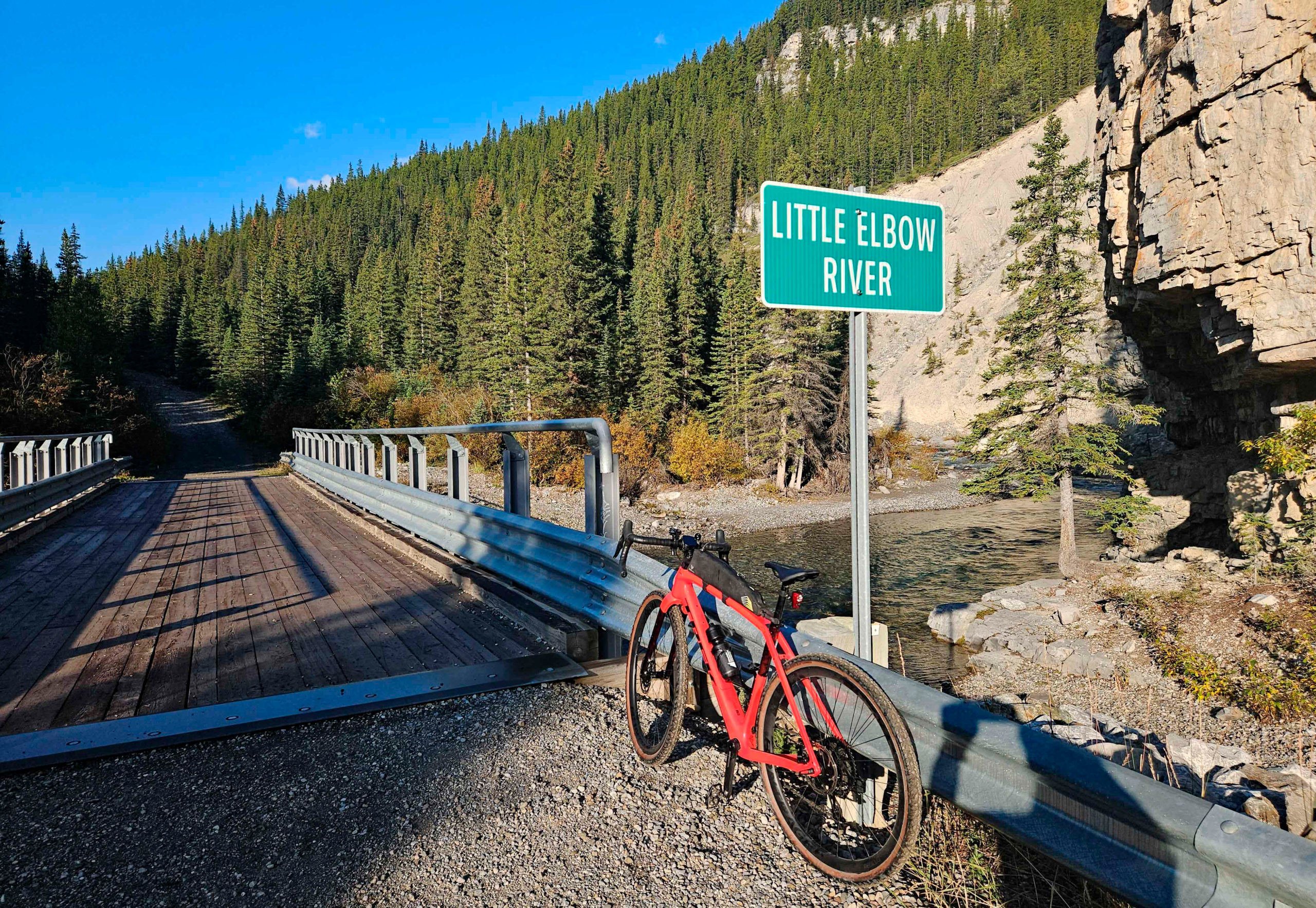
As I had read, the gravel trail was relatively smooth and fast, only the gradient slowed me up. Not that the trail climbed continuously as there were several dips and steeper climbs where now-dry streams cut across my path. The trail continued slowly upward but the first distinctive feature was a bridge over the Little Elbow River about 4km from the trailhead. Built for vehicles, this bridge dispelled any myth that this was wilderness hiking path even though there was no public vehicle access. It was not the sort of trail I would have chosen for hiking in the mountains.

I continued heading southwest, admiring views up the river where it wended from one valley side to the other. None of the short ramps up to this point had been noticeably long or steep until I passed the Mount Romulus wilderness campground. A wide gully crosses the trail here that was presumably feed by meltwater from the back of Mount Cornwall. In late summer, though the gully was a bone-dry dip of rubble. Fortunately, sufficient foot- and wheeled-traffic had tamped the rubble down so it was possible to cycle across. Beyond the gully was the first real challenge with a longer ramp at 13% gradient.

After the gradient had dropped to something gentler, I was irritated to hear the sound of a motor vehicle slowly grinding its way up the hill behind me. At the top of a rise, I pulled over to let it by and, as I suspected on this closed road, it was an Alberta Parks pickup truck. The driver, an outdoors-looking guy of my age with a weather-beaten face, let me know another pickup was half an hour behind him. I had no intention of still being on the Little Elbow Trail by then.

The trail continued both to climb and to swing to the south while the long, grey ridge of Tombstone Mountain appeared on my right across the Little Elbow Valley. Meanwhile, the trail climbed higher above the level of the river. A footpath branched off the trail and dropped down to Tombstone Lakes but a sign warned no, camping, no fires and no bikes.

Gradually, my trail began to level out in an open, U-shaped valley with coarse brown grass and stunted evergreen shrubs. The views southwards stretched on forever where the broad saddle dropped down to the Big Elbow River. My head unit indicated I was only 3km from the junction with the Big Elbow Trail so I was content to let the speed build up initially. When the gradient increased to over 12%, I was continually pulling on the brakes, so much so that my hands started to ache. Consequently, I was happy to slow and stop for a short chat with a bearded guy porting a 50lb backpack. He mentioned he hadn’t seen any bears and that was headed for a campsite I’d not heard of.

Continuing downhill, I was relieved when the signpost for the Big Elbow Trail appeared and I could stop braking. The ride up to that point had taken me two hours and even though it wasn’t quite 11am, I ate half my lunch sandwich. I realized then the circuit was not going to take the five hours I’d anticipated. Mistakenly, though, I imagined getting back to the start from that point in under an hour.

There’s a short rise up at the start of the Big Elbow Trail, that I assumed was the “fearsome ramp” described by other riders. Even though it was single-track, the trail was deceptively smooth at this point. Very quickly, though the descent became steeper, more technical and strewn with grapefruit-sized rocks. Where dry streams crossed, the rocks in the beds often made the route un-cyclable on a gravel bike.

As I rounded one corner, I startled a dark-coloured Spruce Grouse that was rooting around shrubs and had no intention of moving very far out of my way. It was the only wildlife I came across on the whole ride, confirming to me that this route was a heavily-travelled trail.
About 3km along the Big Elbow Trail, I had to walk up the steep, rubbly slope that appeared immediately after a drop down into a gully. Above me I could hear people talking and, as I reached the crest, I found myself among six mountain bikers. Some of their bikes were electric and one of the riders was wearing a downhill biker’s helmet. There were impressed to see I was on a gravel bike with no suspension although they did think assume it was electric.

Immediately beyond the mountain bike group, the route descended a steep slope flanked by and even steeper drop down to the river on my right. With rocks on the narrow path and the steep gradient, I found this part too dodgy to ride. The wheel would skid out if I kept the back brake on but the bike would run too fast into rocks if I let it run. Dismounting though was tricky too and I almost fell down the slope on the right. This wouldn’t be the only descent I had to walk down on this trail and I was beginning to ponder the wisdom of using the gravel bike. The whole time while descending this part of the trail, my shoulders and arms were tensed up and . I sensed my pulse quickened. The going was very slow even though I was travelling downhill.

Seven kilometres from the junction, I came to a footbridge over the Big Elbow that was followed by some faster double track trail before a short climb back up across rubbly slopes and then a descent back down to the river. I made the mistake of heading for the old, washed-out bridge and had to back track to a high suspension bridge to make my way over to the left bank again. My route map was confused by the rerouting and I wasn’t expecting to be heading north with the sun on my back at that stage.

I thought the turn into a camping area was the main trail but quickly realized my mistake and continued on the double track following a much wide Big Elbow River. Along this stretch, I had to keep looking for the Forgetmenot Pond on my phone GPS to make sure I was actually going in roughly the right direction and not up some side valley. I wasn’t trusting the route on my head unit at this stage.
Further north, I encountered two guys on Speclialized electric mountain bikes who asked if I had a bike tool so they could adjust a saddle position. I lent them mine wondering, silently, why neither had any tools even though they were undertaking a demanding ride in mountainous terrain. I asked about their power, 500W apparently, “enough to take the edge off the climb.” That was some understatement as I had struggled to keep 300W of power going up the 13% grades on the other side of the mountain.

Beyond these two, the track followed the edge of the wide river bed until I cut over to the Little Elbow River for another crossing. The trail once again lead me down to the site of a washed-out bridge so I had to climb up to the new footbridge to reach the Forgetmenot Pond side of the river. The final stretch from the bridge to Forgetmenot Pond was flat and fast.
I arrived at the car at 12:50 so the ride of 45km had taken me 3 ½ hours. For the initial 10km, I had managed 12kph but as the climb steepened my speed dropped to 8.5kph. The 3km from the high point to the Big Elbow Trail was a fast downhill at 20kph but progress on the Big Hill Trail was slow (12kph) even though, overall, it was downhill. Even the last 9km, I only averaged 15kph. So, my overall average speed was a modest 12.5kph with 20 minutes total stoppages. I went with 22psi in the front tire and 24psi in the rear and those settings worked well for the terrain.

Did I enjoy the ride? Yes, certainly, but descending on steep loose trails was unpleasant at times as the terrain was better suited to a full suspension mountain bike with wider tires. I wouldn’t ride it again on a pure gravel bike but I enjoyed the challenge. Gravel riding should be more of a flowing experience without the jarring of long, rough descents. Would I recommend riding ride this on a gravel bike? No, it’s a great route but I’ll be seeking out more suitable gravel trails in future.